从坐标文件mdb中生成图形_批量
时间:2022-03-15 15:59
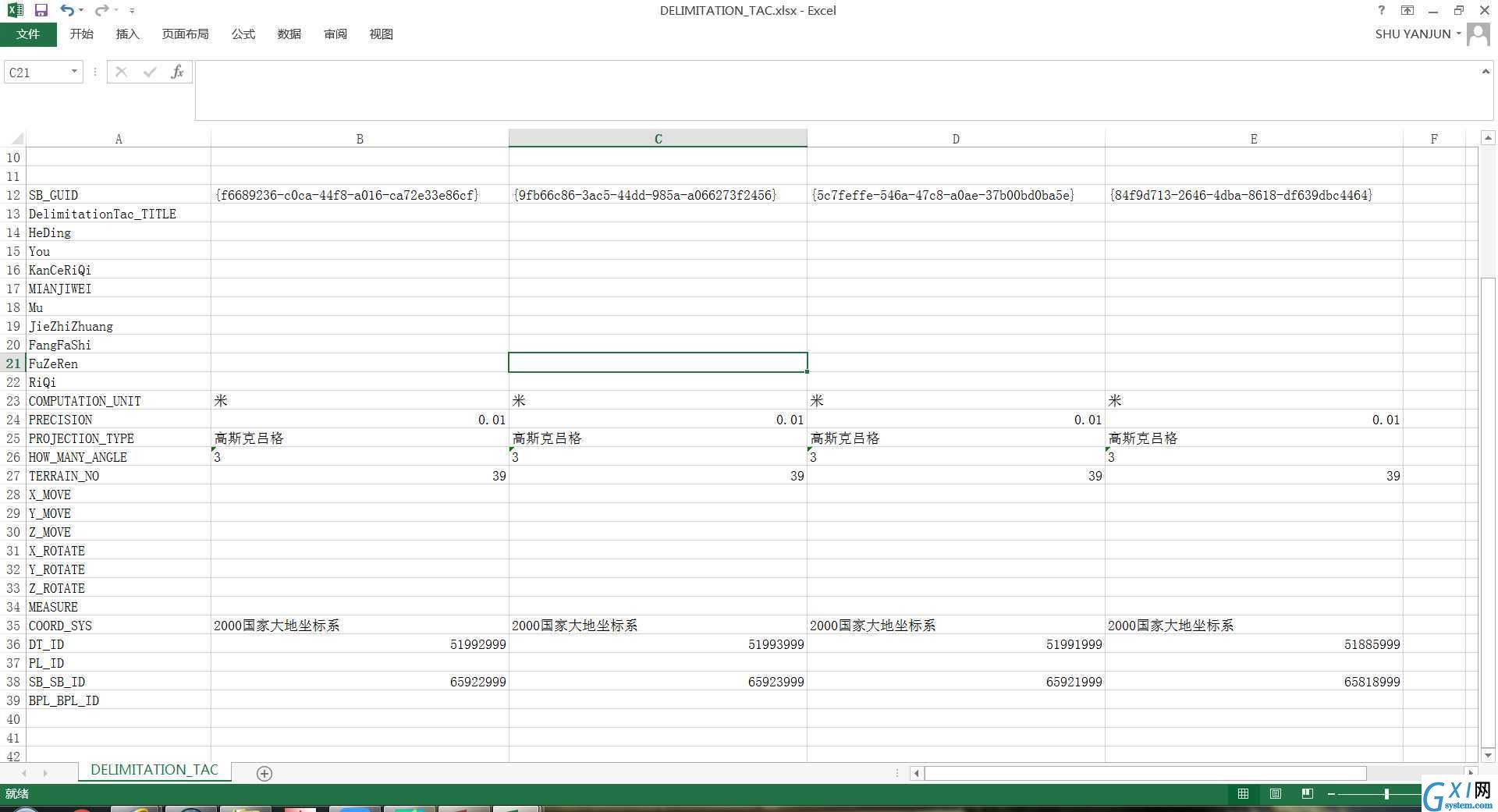
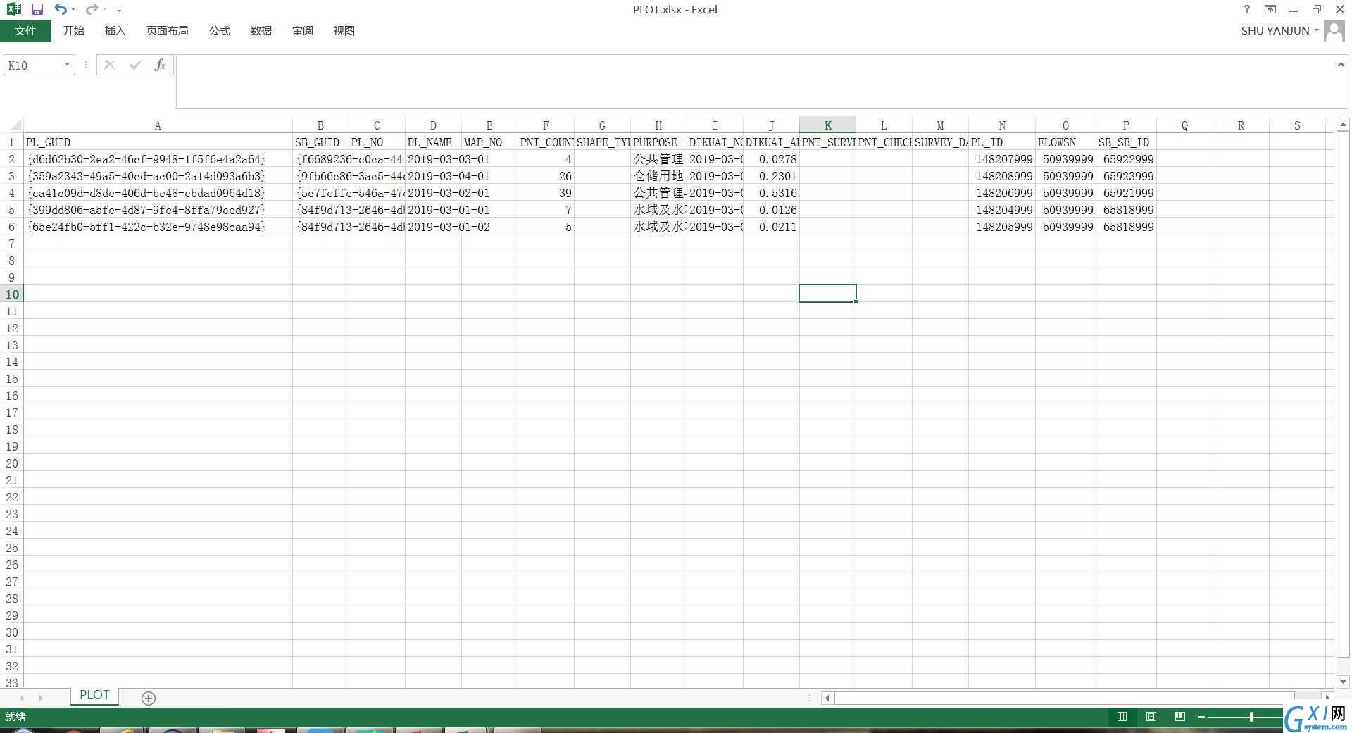
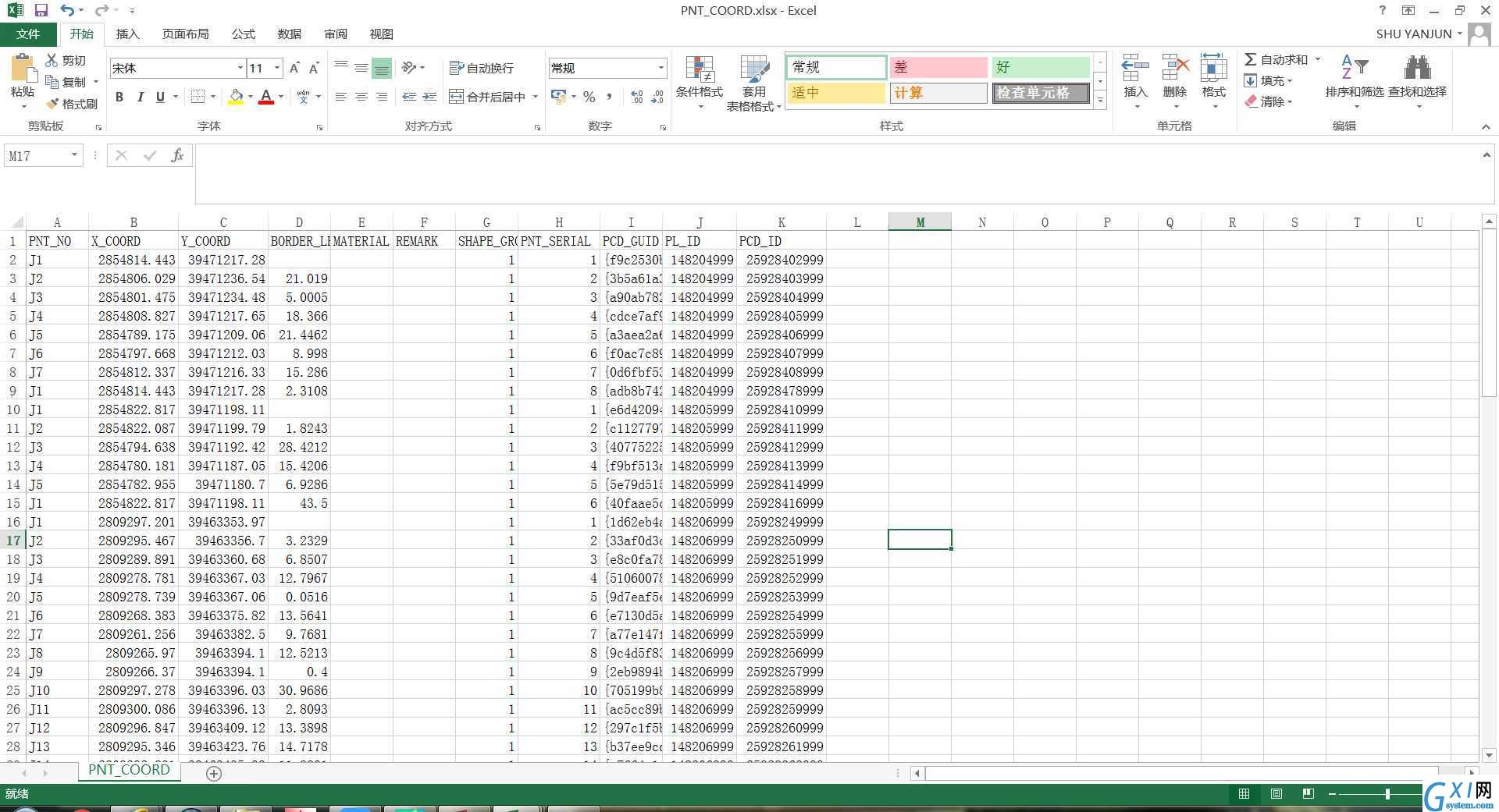
# -*-coding:utf-8-*- import arcpy import pyodbc import os # 指定工作空间 arcpy.env.workspace = r"E:\shp" # 2000坐标系 fc_2000 = "YDBP_2000.shp" cursor_2000 = arcpy.da.InsertCursor(fc_2000, ["FLOWSN", "XMMC", "KCID", "DKID", "COOR_TYPE", "SHAPE@"]) # 80坐标系 fc_80 = "YDBP_80.shp" cursor_80 = arcpy.da.InsertCursor(fc_80, ["FLOWSN", "XMMC", "KCID", "DKID", "COOR_TYPE", "SHAPE@"]) # 未知坐标系 fc_unknown = "YDBP_unknown.shp" cursor_unknown = arcpy.da.InsertCursor(fc_unknown, ["FLOWSN", "XMMC", "KCID", "DKID", "COOR_TYPE", "SHAPE@"]) # 根据需要设置变量:流程号、项目名称、勘测定界ID、地块ID、坐标系类型 FLOWSN = "" XMMC = "" KCID = "" DKID = "" COOR_TYPE = "" count = 0 # 遍历每个mdb文件 path = r"E:\LYMDB" mdblist = os.listdir(path) try: for mdbfile in mdblist: # 获取项目名称 XMMC = mdbfile[:-4] print XMMC.decode("gb2312") + " is beginning..." # 获取mdb文件的完整路径 mdbfullpath = os.path.join(path, mdbfile) # 根据本机的驱动程序编写连接字符串 # mdbsource = r‘DRIVER={Microsoft Access Driver (*.mdb,*.accdb)};DBQ=‘ + mdbfullpath + ‘;‘ mdbsource = r‘DRIVER={Microsoft Access Driver (*.mdb)};DBQ=‘ + mdbfullpath.decode("gb2312") + ‘;‘ with pyodbc.connect(mdbsource) as dbconn: cur = dbconn.cursor() # 根据勘测定界技术说明,获得勘测ID与坐标系的对应关系 xysql = "select * from DELIMITATION_TAC order by SB_SB_ID;" cur.execute(xysql) xyalldata = cur.fetchall() xynum = len(xyalldata) xydict = {} if xynum > 0: for xyid in range(xynum): xydict[xyalldata[xyid][26]] = xyalldata[0][23] # 根据勘测定界表,获取FLOWSN,勘测ID与地块ID的对应关系 kcidsql = "select * from PLOT order by PL_ID;" cur.execute(kcidsql) kcidalldata = cur.fetchall() kcidnum = len(kcidalldata) kcdict = {} if kcidnum > 0: FLOWSN = kcidalldata[0][14] for id in range(kcidnum): kcdict[kcidalldata[id][13]] = kcidalldata[id][15] # 根据坐标点顺序升序排序,并获取界址点成果表 sql = "select * from PNT_COORD order by PL_ID,PNT_SERIAL;" cur.execute(sql) alldata = cur.fetchall() # 计算成所有坐标行数,包括表头 rownum = len(alldata) # 存放坐标点的列表 polygonarray = arcpy.Array() # 根据需要,设置字段 PNT_SERIAL = "" PL_ID = "" # 遍历读取坐标表中的坐标 for i in range(1, rownum, 1): row = alldata[i] X_COORD = row[1] Y_COORD = row[2] PNT_SERIAL = row[7] PL_ID = row[9] # 对DKID第一次赋值 if DKID == "": DKID = row[9] # 生成坐标点 pnt = arcpy.Point() pnt.ID = int(PNT_SERIAL) pnt.X = float(Y_COORD) pnt.Y = float(X_COORD) # 如果地块ID发生变化,说明包含多个地块 if DKID == PL_ID: polygonarray.add(pnt) else: # 生成面要素 poly = arcpy.Polygon(polygonarray) # 根据地块ID找到对应的勘测ID KCID = kcdict[DKID] # 根据勘测ID获取坐标系类型 COOR_TYPE = xydict[KCID] # 追加到要素类中 if COOR_TYPE == u"80国家大地坐标系": cursor_80.insertRow([FLOWSN, XMMC, KCID, DKID, COOR_TYPE, poly]) elif COOR_TYPE == u"2000国家大地坐标系": cursor_2000.insertRow([FLOWSN, XMMC, KCID, DKID, COOR_TYPE, poly]) else: cursor_unknown.insertRow([FLOWSN, XMMC, KCID, DKID, COOR_TYPE, poly]) # 将新的地块ID赋值给fid DKID = row[9] # 清除掉之前的坐标点,并将当前坐标点添加到polygonarray中 polygonarray.removeAll() polygonarray.add(pnt) if polygonarray.count > 0: # 生成面要素 poly = arcpy.Polygon(polygonarray) # 根据地块ID找到对应的勘测ID KCID = kcdict[DKID] # 根据勘测ID获取坐标系类型 COOR_TYPE = xydict[KCID] # 根据不同的坐标系,追加到不同的图层中 if COOR_TYPE == u"80国家大地坐标系": cursor_80.insertRow([FLOWSN, XMMC, KCID, DKID, COOR_TYPE, poly]) elif COOR_TYPE == u"2000国家大地坐标系": cursor_2000.insertRow([FLOWSN, XMMC, KCID, DKID, COOR_TYPE, poly]) else: cursor_unknown.insertRow([FLOWSN, XMMC, KCID, DKID, COOR_TYPE, poly]) # 计数,便于统计 count = count + 1 print mdbfile.decode("gb2312") # 关闭mdb连接 dbconn.close() # 将变量初始化 FLOWSN = "" XMMC = "" KCID = "" DKID = "" COOR_TYPE = "" print "一共上图{0}个...".format(count) except Exception as e: print e.args # 删除图层游标,释放资源 if cursor_2000: del cursor_2000 if cursor_80: del cursor_80 if cursor_unknown: del cursor_unknown
截图如下: